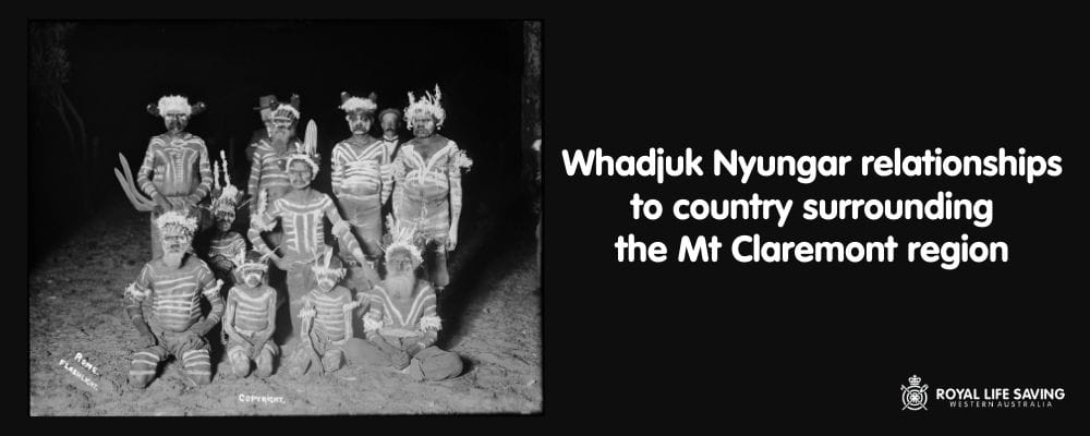
Image courtesy State Library of Western Australia <slwa_b2539794_1>
Aboriginal history of Mount Claremont
As we celebrate National Reconciliation Week, Royal Life Saving WA pays respect to the Aboriginal elders, past and present, who resided on and managed the land on which we now have our office. Reconciliation is a journey for all Australians – as individuals, families, communities, organisations and importantly as a nation. At the heart of this journey is gaining a deeper understanding of the relationships between the broader Australian community and Aboriginal and Torres Strait Islander peoples and their history.
Royal Life Saving Society WA’s head office is located on McGillivray Road in Mount Claremont. One of the members of our Aboriginal Steering Committee, Donna Oxenham, recently compiled an Aboriginal history of this area, and her findings are summarised below. The greater Perth area and much of the lower southwest region of Western Australia, is home to the Nyungar people. The breadth of Nyungar country ranges from highly populated urban regions to more remote rural lands and expands to Geraldton in the north and to the east of Esperance in the south east.
This greater Nyungar region can be broken down into 14 dialectal groups, and the Perth metropolitan area is part of the Whadjuk Nyungar dialect region. More specifically, the Mount Claremont area, where our office resides, originally belonged to the Mooro Whadjuk people who were led by Nyungar leader and elder, Yellangonga until his death in 1835.
Traditional History
 Prior to British settlement, the Nyungar people lived in a structured society in which they shared a common language with a variety of dialects and a body of law and custom that governed day to day existence, how lands are passed on and inherited through the generations and set outs obligations to each other and to people’s traditional lands. These laws and customs are derived from the Nyitting, which is generally known as ‘the Dreaming’, and is a complex of beliefs, values, laws and religio-cultural concepts that are often told through metaphorical stories and song.
The lands on which we reside were traditionally Nyungar hunting grounds. The waterways and freshwater lakes especially, have always been historical locations for Aboriginal campsites – providing an abundance of food such as fish, water fowl, snakes and lizards, plus bush foods and fresh water for the Nyungar people.
Most importantly, the waterways are intrinsic to Nyungar spiritual beliefs and tie into their creation stories relating to the Waugal (great serpent). Nyungar people believe that the Waugal dominates the earth and the sky and makes the koondarnangor (thunder), babanginy (lightning) and boroong (rain). During the Nyitting, it created the fresh waterways such as the bilya/beelier (river), pinjar (swamps, lakes) and ngamma (waterhole). The Darling Scarp represents the body of the Waugal, which created the curves and contours of the hills and gullies. As the Waugal slithered over the land, its track shaped the sand dunes, its body scoured out the course of the rivers, where it occasionally stopped for a rest, and created bays and lakes… The Waugal also joins up with wetlands such as Herdsman Lake and Lake Monger and resides deep beneath underground springs.
Historically, Mt Claremont is situated within the region of these wetlands, with the river to the south, the ocean to the west and Kings Park in the east. Due to these factors, there is a sense of connectivity of this part of the landscape to a broader system through which the bidi or pathways of the Nyungar people traversed, linking surrounding lands.
As waterways, lakes and wetlands are of key importance to Nyungar people for religio-cultural reasons and as places where high levels of food resources are present, the area where Royal Life Saving WA’s head office is situated was an area of high activity in the times of traditional Nyungar society. It’s a place that lies in the centre of a number of traditional cultural and spiritual runs of the Ballaruk and Didjarruk people who have travelled this way since the Dreamtime as they followed the freshwater springs and lakes that enabled their survival.
Contemporary History
By the turn of the twentieth century, European settlement was expanding rapidly, placing pressure on Nyungar populations that lived within and around what is now the Perth metropolitan area. As movement for Nyungar people was becoming restricted, a number of semi-permanent Aboriginal camps were established around the metropolitan area with many in the Lake Monger, Jolimont, Daglish, Shenton Park, Lake Claremont and Fremantle areas.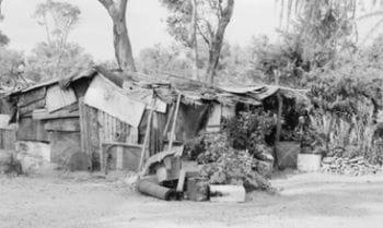
There were a number of camps around the Mount Claremont area including Mr Nell’s Property, Narla Road Camps, Granny Briggs’ Camps, and camps at the location where Claremont Pool is now situated. These camps were generally adjacent to fresh water sources such as lakes or wetlands and were developed on traditional camping areas abundant in food such as turtles, birds and eggs, reptiles and edible species of plants.
The camps were occupied from about the 1920s to the late 1950s and early 1960s and were typically made of whatever materials could be sourced, including scrubs, sticks and tin. Although makeshift due to the lack of support from the State, these camps provided the primary mode of accommodation for Aboriginal people in the area. Lynette Coomer, who lived in the camps around Mount Claremont as a child, says despite the fact that living was rough there she wouldn’t have traded it for the world. “I find that children are fascinated that I used to live in the bush. I said, ‘But that was the best home, that was my first home, that’s my best home I’ve ever had.’” The camps in this area were closed when residents were moved to camps in the eastern metropolitan area by the Native Welfare Department to facilitate residential development.
 An extensive history of the camps has been recorded and published by Dr Denise Cook who says they served a good purpose. “It was very, very hard for Aboriginal people to rent a house and most of them didn't have the money to do it anyway. They were kind of forced into camps. It was the kind of land where they could be on the outskirts of suburbs where they could get work and find water but also far enough from houses that they would be more or less left alone. I want people to understand that it's a shared history. We don't just have this white history — we have all these different layers and elements. It brings a richness to our history that otherwise wouldn't be known.”
It is clear that Nyungar people have had a long and rich history with the lands surrounding Royal Life Saving WA’s Head Office in the Mount Claremont region, and as we continue to develop the next phase of our Reconciliation Action Plan we will continue to engage with the members of our Aboriginal Steering Committee to better understand how we can respect this shared history of the lands on which we lived and work.
Sourced from the collections of the State Library of Western Australia and reproduced with the permission of the Library Board of Western Australia.
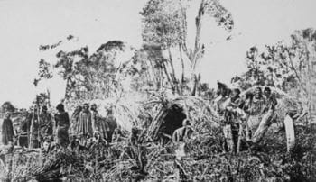
A Traditional Nyungar camp at Crawley, near the current site of the University of Western Australia, c 1860s, State Library of Western Australia, 5033P
Camp at Jolimont, 1957, West Australian Newspapers Limited, V2657
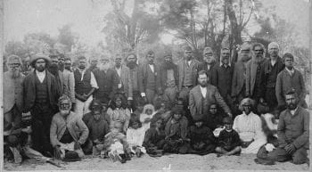
Group portrait of Noongar men, women, and children. Fanny Balbuk sitting front row, second from right. Before 1907. State Library of Western Australia.